
Written by Greg Gillinger
On 16 June 2026, China launched a Long March 3B/E from Xichang carrying Shijian-31 (SJ-31) (69570).
Initial TLE data from SpaceTrack indicates the satellite is operating in a highly elliptical orbit (HEO) with an inclination of approximately 63.4° and an eccentricity of 0.69—consistent with a Molniya-type orbit. The satellite has an orbital period of approximately 12.5 hours, completing just under two orbits per day. China has released little information on SJ-31, stating only that it will be used for “space environment detection.”
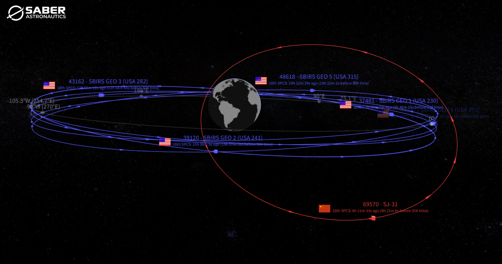
Molniya orbits take advantage of Earth’s oblateness (J2 perturbation) at the critical inclination of approximately 63.4° to stabilize the Argument of Perigee over time. SJ-31 is China’s fifth HEO satellite, joining SY-10 01 (49258), SY-10 02 (54878), TJS-13 (62188), and TJS-21 (66586). China has synchronized the orbits of SY-10 01 with TJS-13 and SY-10 02 with TJS-21 to provide “dual ball” missile warning coverage over the Northern Hemisphere. While all 5 satellites share similar inclination and eccentricity values, China has deployed SJ-31 into an orbit unsuitable for detecting heat signatures rising over the Arctic; rather, the satellite is in a unique position to loiter over the equator, an advantageous location for monitoring satellites orbiting in the Geosynchronous belt. Adding to the intrigue, given SJ-31’s orbit, characterizing its capabilities will be quite sporting… maybe impossible.
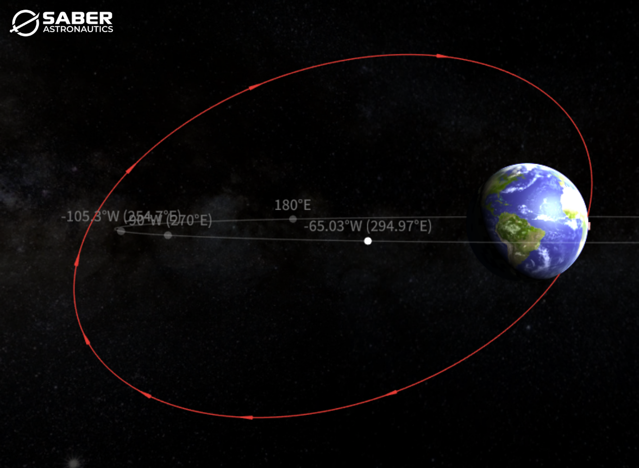
SJ-31’s orbital configuration is unusual. Traditional Molniya orbits are oriented to place apogee over the northern hemisphere, typically achieved with an Argument of Perigee near 270° (China’s other 4 HEO satellites share this trait), thereby maximizing dwell time at high northern latitudes. For comparison, Shiyan-10 02 (54878) operates in a more typical Molniya orbit, with apogee positioned over the northern hemisphere and an Argument of Perigee near 270°, prioritizing high-latitude coverage.
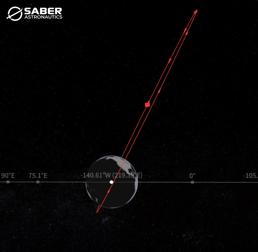
SJ-31 instead has an Argument of Perigee of approximately 171°, placing apogee just south of the equator as the satellite approaches its ascending node. This results in extended dwell time over equatorial regions rather than the Arctic.
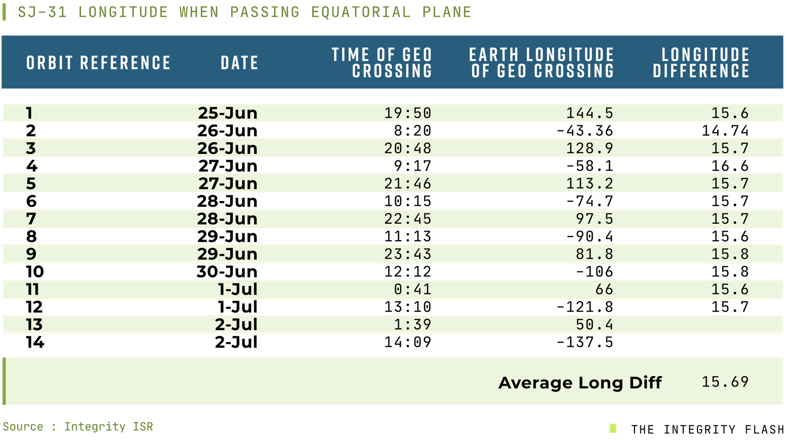
SJ-31 intersects the equatorial plane as it heads toward apogee every 12 hours and 30 minutes. Because its orbital period is slightly longer than the standard 12-hour Molniya orbit, the satellite does not cross the equatorial plane at the same longitude on each pass. Instead, the crossing location shifts slightly along the GEO belt with each orbit.
When comparing equivalent crossings—such as one ascending-node pass to the next ascending-node pass—the longitude shifts by approximately 15.7° per cycle (see table). Because the satellite completes just under 2 orbits per day, these shifts occur in two interleaved sequences (odd and even orbit passes), each progressing by approximately the same amount.
The result is a gradual longitudinal progression around the GEO belt. Rather than repeatedly crossing the same region, SJ-31 effectively “walks” its interaction point around GEO. At this approximate rate, the satellite completes a full 360° progression around the GEO belt in roughly 23 days. This orbital geometry is well-suited for observing the entire geostationary orbital regime.
SJ-31 crosses the equatorial plane at altitudes roughly 2,000–2,500 km above where GEO satellites reside, providing recurring, safe, and extended opportunities to observe and track GEO residents, although the distances involved likely limit imaging to unresolved detection. Other types of intelligence collection sensors could also benefit from this geometry.
For interested, non-Chinese observers, identifying SJ-31’s sensors and capabilities will take some creativity. At perigee, SJ-31 operates at just under 2,000 km—well above typical LEO imaging satellites (400–600 km). At this distance, even the best imaging satellite could only hope to get a few pixels of SJ-31 as it speeds through perigee. At apogee, it remains thousands of kilometers away from known GEO inspection satellites, making high-resolution observation impossible for typical GEO inspectors like the US GSSAP vehicles.
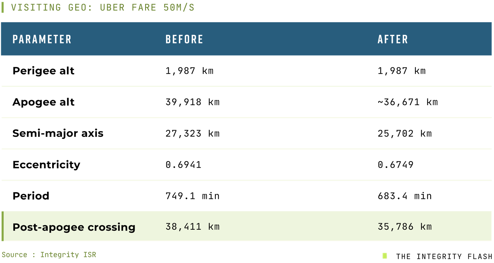
If China ever decided to have SJ-31 intersect the equatorial plane at GEO altitude (~35,786 km), this could be achieved with a relatively modest propulsion maneuver. Specifically, a retrograde burn of approximately 50 m/s at perigee would lower apogee to roughly 36,671 km, resulting in SJ-31 passing directly through the GEO neighborhood as it completes its orbit.
With SJ-31, Chinese space operators have displayed orbital mechanics mastery and more than a little creativity. While Molniya orbits are well understood, this specific orientation—and its resulting relationship with GEO—is not typical. SJ-31’s orbit—and its evolving relationship with the GEO belt—is mandatory viewing.

Meet the Author: Greg Gillinger: With 26 years in the U.S. Air Force and a career spanning strategic intelligence, space operations, and national security, Greg Gillinger brings unparalleled expertise to Integrity ISR.
As Senior Vice President for Strategy & Development, Greg plays a pivotal role in advancing Space ISR capabilities and shaping the future of intelligence operations.
From leading ISR divisions at 14th Air Force and CSpOC to serving on the National Security Council, Greg’s experience reinforces Integrity ISR’s mission—delivering elite training, cutting-edge strategy, and operational excellence to defense forces worldwide.
We’re honored to have Greg’s leadership guiding our mission and proud to feature his insights through Integrity Flash.
Read more articles just like these at theintegrityflash.com